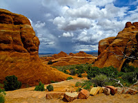
Driving north from Monument
Valley, we passed more interesting geologic formations – one definitely looked
like a Mexican sombrero, and the local community was named Mexican Hat.
There was signage for other points of interest, such as natural bridges and newspaper rock, but we were ready to reach Moab and our spot for the next week in Portal RV Park.
There was signage for other points of interest, such as natural bridges and newspaper rock, but we were ready to reach Moab and our spot for the next week in Portal RV Park.
Moab is a small town full of
recreational outfitters, lodging locations, restaurants, and great little art
galleries housed in 1950s – 60s buildings.
Everyone we have met is friendly and helpful – given that uranium mining
here is part of their history, and that tourism is probably the primary current
influx to the local economy, I suppose that a good thing!
Note the "foliage" in the Peace Tree Cafe sign. This was a popular cafe - we had a great breakfast; their menu includes vegan and gluten free items. In the evenings, most diners were outside with the roses.
This is a great town to
explore, and, our “exploration” started as soon as we got here (when Gary
noticed the electrical signals cable from the RV to the tow car had severed
during this leg of the trip). Luckily,
the NAPA car parts had the makings for a replacement and we’re good to go
again.
 |
Old uranium building - now used for small shops downstairs |
Note the "foliage" in the Peace Tree Cafe sign. This was a popular cafe - we had a great breakfast; their menu includes vegan and gluten free items. In the evenings, most diners were outside with the roses.
The national parks gift
shops have T-shirts with a non-tech definition for the many geologic formations
we are seeing –
The Geologic Story of UT –
“Depositing, layering, carving, eroding, faulting,
sliding, petrifying, lifting, freezing, collapsing, folding, and flowing”
And this 300 million year
set of occurrences continues today!
Geology truly rocks!
Just north of Moab is Hwy
128 – a Colorado River Canyon scenic byway.
We decided to take a day trip up the river and check out some
interesting stops along that route.
Recommended by the Moab information center, this area of the Colorado River Canyon system was settled by ranchers looking for grasslands for cattle about a century ago. Later, several ranches were used as locations for movies and commercials, often in conjunction with filming in Monument Valley.
Recommended by the Moab information center, this area of the Colorado River Canyon system was settled by ranchers looking for grasslands for cattle about a century ago. Later, several ranches were used as locations for movies and commercials, often in conjunction with filming in Monument Valley.
Traveling down this highway,
it is easy to see why the area was chosen first for ranching, and later for
film locations.

Our first stop was a site called Negro Bill Canyon. The namesake for this canyon was an early settler (1877) and successful cattle rancher named William Granstaff. For whatever reason, the name of the canyon hasn’t been undated.
Hiking up the canyon leads to a turnoff and then to the Morning Glory Natural Bridge (debate exists as to whether this 243 foot wonder is an arch or bridge). The roundtrip hike is 4-6 miles (depending on the source) and involves crossing the flowing creek about 10 times, AND there was mention of lots of poison ivy along the way. Since we did not have water sandals, we opted to put this hike on hold – though seeing the bridge/arch would have been great.
We did stop at the Red
Cliffs Lodge compound and checked out their winery and also visited the movie
and cowboy history museum at the lodge.
The museum was free and helped explain the collaborations built between
“Hollywood” and local families from Moab to Monument Valley. One display showed many locals who held jobs as location scouts and managers. We spotted the picture of Fred who was our guide at Monument Valley. He was a bit younger then!
Lunch at the lodge was a
great buffet at their covered river deck.
The buffet including old newsreels of early boating trips down the
Colorado; then we watched some rafts taking off for the afternoon.
Departing the lodge, we traveled a little further upstream and checked out a couple sites used in various films – Fisher Towers and Castle Rock.
At Fisher Towers, there were numerous climbers top of the spires - magnifying glass probably needed to pick them out!
Departing the lodge, we traveled a little further upstream and checked out a couple sites used in various films – Fisher Towers and Castle Rock.
At Fisher Towers, there were numerous climbers top of the spires - magnifying glass probably needed to pick them out!
 |
| Castle Rock (famous for car on the top of spire commercials) |


Check out our friends David and Mary's blogs. They were just hiking in Canyonlands. https://marygardner.wordpress.com
ReplyDeleteDon't remember having to wade through water on Negro Bill's trail but it sounds like you've had lots of rain.
They have a great blog! They were in the Needles area of Canyonlands. We only made it to the Island in the Sky area. Just a short trip with a trip to Mesa Arch and a walk along the canyon rim. Will have a post on it soon. Today we went back to Arches and in your honor went to a brewpub - Moab Brewery.
Delete